The Map is not the Territory.
Posted: March 26, 2012 Filed under: Education | Tags: education, higher education, Korzybski, measurement, reflection, teaching, teaching approaches 3 CommentsI’m writing a paper on visualising Internet network topologies with my PhD student and some colleagues at the moment and an old friend, who is one of the student’s other supervisors, looked at some of the work we’d been doing and mentioned a great quote from Alfred Korzybski in 1931:
“The map is not the territory.”
Korzybski was a philosopher and scientist who developed the theory of general semantics, which I’m not going to talk more about here, but a lot of his work revolved around the idea that all we have access to is perceptions and beliefs, which we confuse with a knowledge of actual reality. This is a simple quote and a powerful concept: one of my favourite combinations.
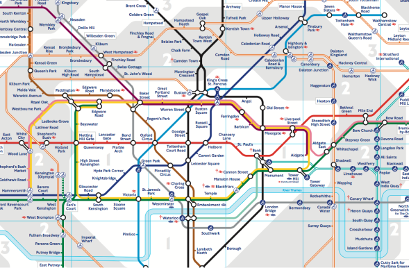
What brought me to this was that, as part of our paper, we were looking at the London Underground map – the famous Tube Map.
The focus of the Tube map is getting around London by Tube. Designed in 1931 by Harry Beck, a draughtsman with experience in laying out electrical circuits, it replaced a large number of incomplete and more geographically focused maps. What is most interesting about this map is that some licence is taken with the geography in order to make this the simplest map to use for Tube travel. Above ground, this map is not only not as useful, in some areas it’s completely wrong. (Suburbs on the opposite side shown, distances completely inaccurately represented for ease of reading.)
This has had an effect on the way that people travel around London – making decisions above ground that make sense on the Tube map but are downright silly when on foot on the streets. To combat this, Transport for London have developed the Legible London project with above-ground signage to assist the navigation of London Above, with signs and images showing you directions and landmarks.
Whether it’s maps of networks, maps of London or course pre-requisite diagrams, maps are only useful if you design them correctly for their primary use. Looking at the work on prerequisites that I’ve been talking about recently, it’s becoming more apparent that my desire for a good visualisation of pathways stems from my desire for a map that correctly reflects what we want students to do, reinforces the correct behaviour and is also going to be fit for purpose. Rather than using one diagram for many things, I need to check to make sure if I have the best diagram for a given situation.
Sometimes I need to release my grip on the accuracy of geography (precise location) to focus on the detail of topology (arrangement and connectivity). Sometimes it’s the other way around. Particularly when I insert a temporal aspect, I need to make sure that this “fourth dimension” doesn’t make my maps so complex that they’re useless. However, I always need a reason to relax a requirement: I’m certainly not saying that you can scribble randomly on a piece of paper and call it the NYC Subway map!
But, taking this concept further, how many pieces of work are out there that confuse a good diagram or a flowchart with the real thing? Is this just our confirmation of our perceptions and, as as result, it’s strongly sensible only when viewed from within our context? Or are we producing transferrable and shareable maps, focused on the right detail, showing the correct view of the terrain for the purpose, and accepting that there are an almost infinite set of views of the true territory?
A good map helps us to navigate territory but it can never replace it. What I always need to remember is that if I produce a map from a map, I can add no more detail than was in the original and I cannot correct mistakes in the original, without reference to the territory itself. And that’s something I think that is always worth remembering.


After reading your blog, I had to check your “About” page. Your writing allowed me (not a Ph.D. student) to understand why some maps are incorrect. Although, I do prefer to not use maps. It seems I find some of the most interesting places while I am temporarily lost.
Your last two paragraphs really made me think about what we are doing within our schools here in America. We are working on mapping our curriculum. The idea is that every teacher will be teaching the same skills. As we work on our mapping, I sometimes wonder how well our maps will work.
LikeLike
[…] The Map is not the Territory. […]
LikeLike
[…] written about the difference between the real world and the model before, but let’s just say that “the map is not the territory” and move on. In terms of […]
LikeLike